Irrigation
Present Irrigation System
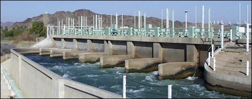
Gila Gravity Canal Headworks at Imperial Dam
Source and Amount of Water
Wellton-Mohawk’s water comes from the Colorado River. Flow is diverted at the Arizona abutment of Imperial Dam, into the Gila Canal, a joint-use facility shared by five Yuma-area irrigation districts. WMIDD’s share of the flow is delivered at Gila Canal Mile 15 into the Wellton-Mohawk Canal.
The District was originally established to serve a maximum of 75,000 irrigable acres, or to consumptively use 300,000 acre-feet of Colorado River water. Consumptive use in the case of Wellton-Mohawk has been defined as the difference between the amount diverted and the amount returned to the Colorado River main-stem as agricultural return flows. Voluntary District participation in the Salt River-Pima-Maricopa Indian Community Water Rights Settlement of 1988 has reduced the allowable consumptive use by the District to 278,000 acre-feet per year. In exchange for giving up this portion of its water allotment, Wellton-Mohawk acquired many long-term benefits.
The District assesses a basic, non-refundable, per-acre Operation and Maintenance charge, which includes payment for the first 4 acre-ft of water. All on-farm water use above the 4 acre-ft per acre minimum is charged at an increasing rate per acre-foot, discouraging careless irrigation practices. The District’s “water right” is one of the most secure on the lower Colorado River.

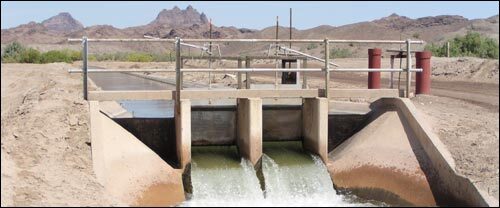
Mohawk Main Canal
Facilities
The District has approximately 378 miles of main canals, laterals, and return flow channels. Additional facilities include 3 major pumping plants (through which passes the entire flow of the main canal at the 3 locations), 4 minor (but in-line, or full-flow) pump stations on three of the larger laterals, 10 re-lift (side delivery) pumps at various locations on main and lateral canals, 90 drainage wells, and about 300 observation wells. The project was originally constructed with a water delivery structure for each 160 acres, or each individually owned smaller parcel. All turnouts were constructed with flow measurement capability. There are no storage or regulating reservoirs within the District.
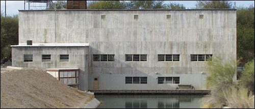
Wellton-Mohawk Pumping Plant #3
The pumping plants lift water from the Colorado River generally eastwardly, “uphill” against the westward slope of the Gila River valley, irrigating the fertile lands along the Gila. The challenge of locating canals and laterals to make the most efficient possible use of a minimum number of pumping facilities was superbly met by the Bureau of Reclamation.
Construction work started in 1949, and the first water was delivered to fields in 1952. Wellton-Mohawk Irrigation and Drainage District, as a legal entity, assumed operation of the first-completed features of the irrigation works in 1953. The power distribution facilities date from 1921 and were taken over by the District upon its legal formation in 1951.
Water is also provided to several small communities, through public or private municipal/domestic water distribution systems. Prior to 1967, there were four small domestic water companies that delivered domestic water (all from groundwater sources) to users within the town of Wellton. On July 26 of that year, a treatment plant and town-wide distribution system were dedicated, with water obtained from the Wellton Canal, under formal contract between the Town of Wellton and the District.
There are also literally hundreds of individual domestic turnouts providing untreated canal water to individual residences. It is the responsibility of the user in all cases to provide adequate treatment of water prior to domestic or residential use. The District provides treated, potable water only to the residential area adjacent to its headquarters, and to several outlying District-owned residences. At the present time, water is provided for industrial uses on a temporary basis only (mining, temporary construction sites, etc).
Dome 1.4E 3.1 Check structure
All canals and laterals are concrete-lined except for 8 miles of the main canal upstream (west) of the first main pumping plant. The absence of lining in this reach is recognition that the water up to this point has been flowing by gravity, and has not yet had pumping costs “invested” in it. Also, some of this 8-mile reach lies below the normal depth of groundwater. Rather than losing water because of the absence of a concrete lining, this reach of the canal can gain water under certain conditions.
As mentioned above, all irrigation water is delivered through flow-measuring devices, either constant head orifices, propeller meters, or broadcrested weirs. In general, recovered groundwater is not used as part of the irrigation deliveries made through District facilities. However, groundwater irrigation, using privately owned wells, does exist within District boundaries.
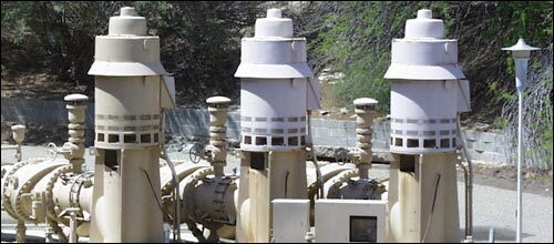
Small Pumps at Pumping Plant #3
In the early 1970s, 3 small pumps were added at each of the main pumping plants, making possible smaller incremental adjustments in the flow through each pumping plant. Justified as energy saving “retrofits”, the additional pumps also decrease the number and size of unusable flows which previously were discharged to the Gila River, or to the main conveyance (return flow) channel.
The District’s water use records are computerized, primarily for accounting, but the system has the additional benefit of improved and practically instantaneous access to water use data for other purposes. Development and installation of a Supervisory Control and Data Acquisition (SCADA) system on the main canals has begun. One of several benefits of a SCADA system is remote control of gates and canal structures. This capability minimizes uncontrolled and unneeded canal flows downstream of points of feasible use, thereby limiting discharges into or through wasteways.
One of the more challenging features of the District is its three-dimensional “geometry”, both surface shape and topography, as well as subsurface characteristics. Because of its long “skinny” configuration, the ratio of miles of ditch to service area is rather high; a more “compact (circular or square) shape would be more efficient. The natural overall uphill slope of the Gila River, as well as the steep transverse slope of the lands adjacent to the Gila River valley made relift pumps necessary, and also contributed to potential drainage problems where varying field elevations adjoin.
At this time, following several periods of adjustment, the District is comprised of approximately 58,200 irrigable acres in the valley and 4,550 acres on the mesa.